Where To Hike In Southern West Virginia
Southern West Virginia is a top destination for hiking, offering scenic trails that wind through forests, across ridgelines and into the heart of the New River Gorge National Park and Preserve. From family-friendly paths and waterfall views to hidden gems and challenging climbs, the region’s trails showcase the wild beauty of West Virginia. Below, you’ll find some of the best places to hike in Southern West Virginia.
Best Trails For Families
White Oak Rail-Trail (easy)
This nearly 8-mile trail runs through the city of Oak Hill, connecting the communities of Summerlee and Carlisle at either end. The trail is mostly paved, with only a short stretch of packed gravel, offering an accessible path that’s great for walking and biking. A highlight of the trail is the White Oak Railroad Depot, which first opened in 1903.
White Oak Rail-Trail Interactive Map
YMCA Loop (easy)
Perfect for hiking, mountain biking and birding, this well-loved trail near Beckley also offers a quiet escape for those seeking solitude. The 4-mile loop is best enjoyed from April through October.
YMCA Loop Interactive Map
Hemlock Trail (easy)
Located at Twin Falls Resort State Park, this 1.2-mile trail gradually descends through a landscape shaded by hemlocks, rhododendrons and a variety of native plants. From the Hemlock Trail, follow the stream and jump on Nature Trail or Falls Trail.
Hemlock Trail Interactive Map
Greenbrier River Trail (easy to moderate)
Extending for 78 miles through rural West Virginia along the Greenbrier River, this rail trail is the longest trail of its kind in the state. The accessible trail is comprised of packed gravel, accommodating hiking, biking and horseback riding. The Greenbrier County trailhead is located just 1.3 miles north of Caldwell.
Greenbrier River Trail Interactive Map
Top Scenic Viewpoints
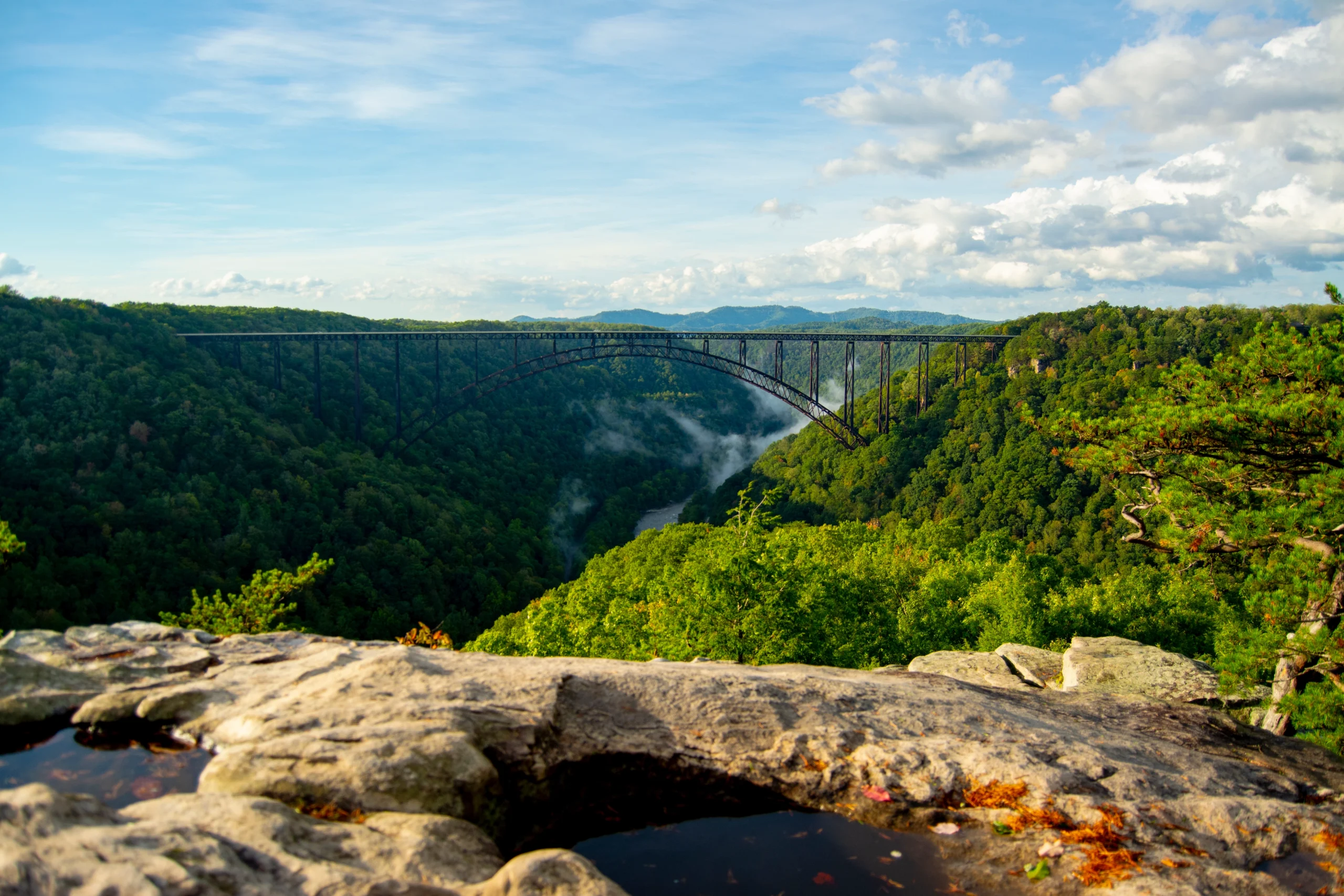
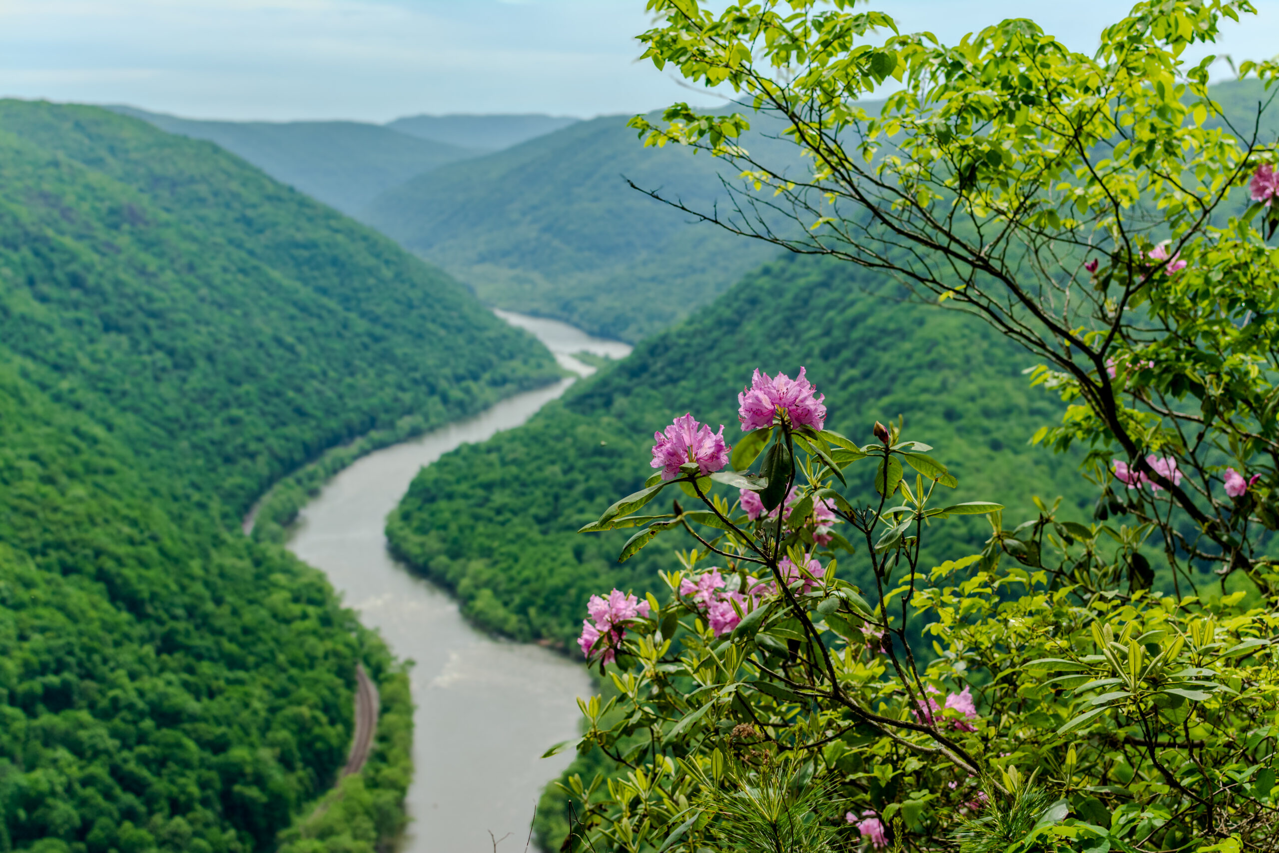
Long Point Trail (moderate)
This 3.2-mile trail offers unmatched views of the New River Gorge Bridge from a rock outcrop at the end, as well as the scenic beauty of the New River Gorge National Park and Preserve.
Long Point Trail Interactive Map
Endless Wall Trail (moderate)
This 2.4-mile trail passes through a rich forest, crosses over Fern Creek, then zig-zags along the cliff edges of the New River Gorge. Many stunning vistas can be seen along this popular trail.
Endless Wall Trail Interactive Map
Grandview Rim Trail (moderate)
The longest hike at Grandview offers a breathtaking view of the gorge. This 3.2-mile round-trip journey will take you to some of the most photographed areas in the state of West Virginia. The surfaces are packed, uneven and can be rocky in some areas.
Grandview Rim Trail Interactive Map
Turkey Spur Trail (easy to moderate)
Located at Grandview, this 3-mile trail is known for its “Air Conditioner” – a large vertical fissure in the sandstone that provides hikers with a dose of cool air. This prepares you to climb 128 wooden steps leading to various overlooks. On a clear day, you can see miles at the base of the stairs.
Turkey Spur Trail Interactive Map
Long Point Trail (easy to moderate)
Explore this 3.9-mile out-and-back trail near Summersville Lake. Generally considered an easy route, this trail is popular for birding, hiking and mountain biking, but it can still be enjoyed for some solitude during quieter times of the day. The trail is open year-round and is beautiful to visit any time of the year. Dogs are welcome and may be off-leash in some areas.
Long Point Trail Interactive Map
Cliffside Trail (moderate to difficult)
Located at Twin Falls Resort State Park, this 3.5-mile trail begins with a gentle slope that becomes rocky and strenuous. The trek rewards hikers with two prominent vistas. Don’t forget to stop and enjoy the thicket of rhododendrons on the outer loop of the trail.
Cliffside Trail Interactive Map
Pipestem Knob Trail to Bolar Lookout Tower (moderate)
This steep 0.2-mile trek at Pipestem Resort State Park leads to the Bolar Lookout Tower atop Pipestem Knob. The top of the tower offers 360-degree views of the surrounding mountain landscape.
Pipestem Knob Trail to Bolar Lookout Tower Interactive Map
Hanging Rock (moderate)
Though the observatory tower is currently closed, the 1-mile trail leading to amazing valley and mountain views is still open.
Hanging Rock Interactive map
Hidden Gems & Local Favorites
Burnwood Trail (easy)
Located across the road from the Canyon Rim Visitors Center, this enjoyable 1.2-mile loop trail follows through rich forest and rhododendron thickets. The trail then continues to the edge of an open field, loops back through the forest and returns to the field. This area was a former home site of the Laing family, with clues of their history found along the trail.
Burnwood Trail Interactive Map
Lake Stephens (easy, moderate, strenuous)
Lake Stephens is home to 20 miles of trails for walking, biking, hiking and horseback riding. The area offers a variety of lengths and degrees of difficulty surrounding the lake. Follow the rolling terrain with several tree identification signs along the way.
Lake Stephens Interactive Map
Salmon Run Trail (moderate)
This 1.9-mile loop near Summersville is great for hiking and mountain biking. Plus, it’s unlikely you’ll encounter many other people while exploring! Dogs are welcome but must be on a leash.
Salmon Run Trail Interactive Map
Turkey Rock Trail (moderate to difficult)
This 1.5-mile trail at Pinnacle Rock State Park forms a loop past a towering rock formation known as Turkey Rock.
Turkey Rock Trail Interactive Map
Almost Heaven Trail (moderate)
This 5.8-mile loop in Camp Creek State Park is ideal for hiking. The best time to hike this trail is April through October. Dogs are welcome but must be on a leash.
Almost Heaven Trail Interactive Map
Challenging Hikes for the Adventurous
Kaymoor Miners Trail (strenuous)
This 1-mile (one-way) forest trail descends steeply from the top of the gorge with switchbacks and stairs to the Kaymoor coal mine site, then crosses the Kaymoor Trail. A view of the gorge is located 0.2 miles down the trail, off to the right, before the stairs. At the mine site, a set of 821 steps continues down to the remains of the coal processing plant, coke ovens and town site near river level.
Kaymoor Miners Trail Interactive Map
Appalachian National Scenic Trail (moderate to strenuous)
The world-famous Appalachian Trail runs over 2,000 miles from Georgia to Maine. A section of the trail runs along the West Virginia-Virginia border in the Peters Mountain Wilderness of Jefferson National Forest. While some spend months training for a thru-hike, day hikers are always welcome on the trail.
Appalachian National Scenic Trail
Allegheny Trail (moderate to strenuous)
The Allegheny Trail is West Virginia’s longest hiking trail. The 311-mile trail runs from the Pennsylvania-West Virginia state border until it reaches the Appalachian Trail on Peters Mountain at the West Virginia-Virginia border. You can make a plan to backpack the entire thing or complete a small section as a day hike.
Allegheny Trail Interactive Map
Waterfall Hikes and River Walks
Glade Creek Trail (moderate)
This 5.6-mile trail follows an abandoned railroad along Glade Creek. The moderate-grade path is popular with hikers of all ages and abilities. A number of cascades and small waterfalls add to the trail’s popularity.
Glade Creek Trail Interactive Map
Kates Falls Trail (strenuous)
This difficult, short hike is a 0.2-mile, steep spur trail leading from the Glade Creek Trail to Kates Falls, a beautiful cascade.
Kates Falls Trail Interactive Map
Clear Fork Rail Trail (easy)
A peaceful 5-mile path through the forest, this multi-use rail trail surprises visitors with a tucked-away waterfall along the way. The trail starts at Jarrolds Valley at 101 Rich Lane, Whitesville.
Clear Fork Rail Trail
Patterson Trail (easy)
This 2-mile easily accessible trail forms a loop around Carnifex Ferry State Park. The trail highlights three beautiful overlooks of the Gauley River.
Patterson Trail Interactive Map
Sandstone Falls Boardwalk and Island Loop Trail (easy)
This half-mile loop and quarter-mile boardwalk make for a relaxing stroll through one of the most biodiverse places in the New River Gorge National Park and Preserve. While the loop trail takes explorers through a successional forest, the boardwalk guides visitors to views of the stunning Sandstone Falls.
Sandstone Falls Boardwalk and Island Loop Trail Interactive Map
Riverview Trail (easy)
Follow this 1.2-mile trail for views of the Bluestone River and the chance of seeing wetland animals. This trail starts just beyond the Bluestone State Park office and ends by the tent camping area.
Riverview Trail Interactive Map
Hawks Nest Rail Trail (easy)
The 1.8-mile rail trail begins at the base of the aerial tram in Hawks Nest State Park and follows Mill Creek toward Ansted. Ideal for a family outing, the trail includes two bridge crossings and views of numerous cascading waterfalls along the way.
Hawks Nest Rail Trail Interactive Map
More Hiking Information
For more information and additional trails winding through Southern West Virginia, visit the New River Gorge National Park and Preserve website and the West Virginia State Parks website.
Safety Tips and Leave No Trace Reminders
It’s up to all of us to keep our trails clean and safe for the next adventurer. The best way to protect our wild and wonderful spaces is by following the Leave No Trace Principles:
- Plan Ahead and Prepare
- Travel and Camp on Durable Surfaces
- Dispose of Waste Properly
- Leave What You Find
- Minimize Campfire Impacts
- Respect Wildlife
- Be Considerate of Others
With your help, we can ensure these special places remain beautiful, thriving and accessible for generations to come. By respecting the land, its critters and its history, we all play a part in preserving the places we love.
Hit The Trails
Explore the trails of Southern West Virginia and share your best photos using #VisitWV for a chance to be featured on our social channels!
Want to see more from our team? Save our blog as a preferred source in Google