Chasing Waterfalls in Southern West Virginia
March 20, 2024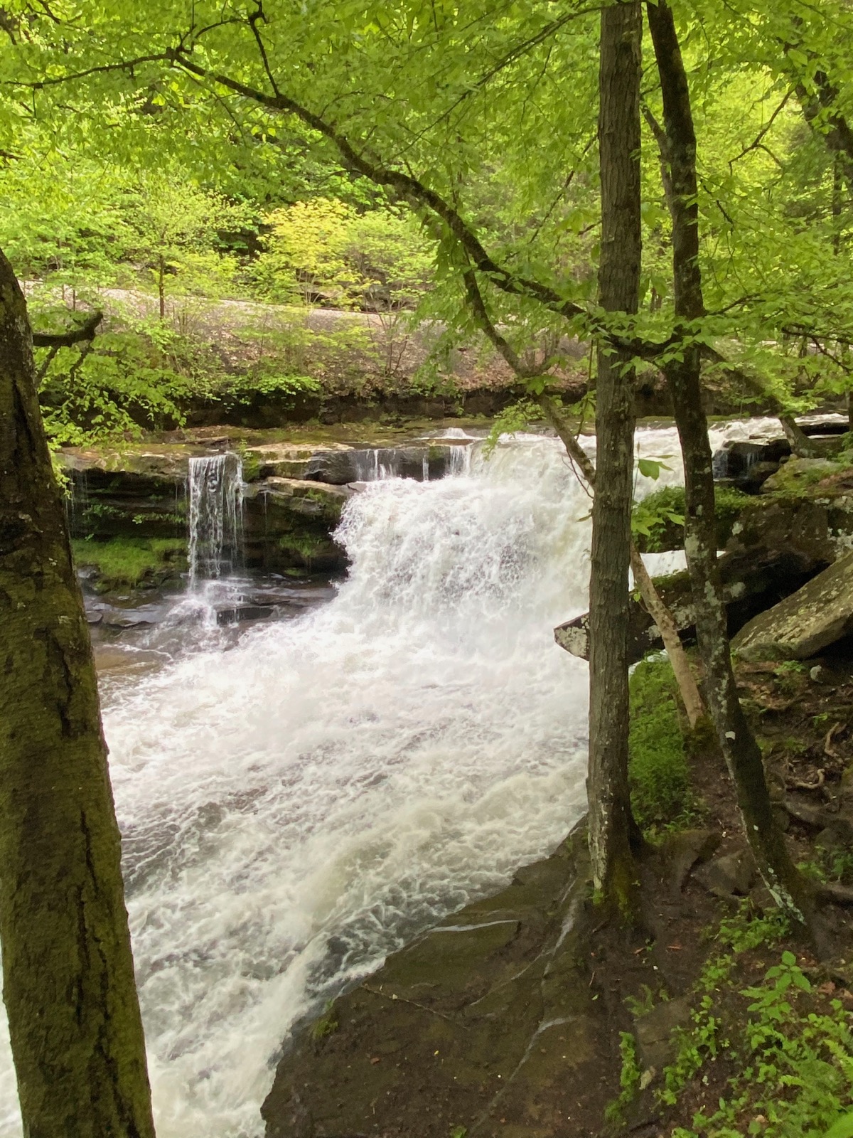
Dunloup Falls
One thing about humans: we’re attracted to water. Something about vacations often leads us to lakes, rivers, and oceans. We just can’t get enough of it, and we love to watch it fall. Give someone a Sunday drive and a picnic next to a waterfall, and it’s like you’ve set the stage to solve the world’s problems. At least for an hour or so. Here are some of our favorite waterfalls in Southern West Virginia to check out on your next trip to the area.
Scenic Views & Endless Experiences
This area of Southern West Virginia encompasses Fayette, Raleigh, and Nicholas counties and is the home of some of the most gorgeous and famous views the state has to offer. Given its location in the New River Gorge Nation Park and Preserve, there is no shortage of waterfalls to explore.
Fayette County
- Cathedral Falls* – Tucked away in a curve on Route 60, Cathedral Falls flows more than 100 feet down a steep mountain canyon. Pull off of the scenic Midland Trail for a closer look. The flow is ever-changing, but it’s always a stunning sight.
- Coordinates: 38.154206, -81.179275 (38° 09’15.1″ N, 81° 10’45.4″ W)
- Glade Creek Falls* – Found along Glade Creek Trail, Glade Creek Falls is a spectacular cascade. The Glade Creek area is beautiful, serene – and packed full of waterfalls. While hiking, keep your eye out for a number of waterfalls along the way. At higher water, you may even spot a whitewater kayaker tackling some of the drops.
- Coordinates: 37.827339, -81.010506 (37° 49’38.4″ N, 81° 00’37.8″ W)
- Kanawha Falls* – Easily spotted from the side of Route 60, Kanawha Falls is a wide cascade on the Kanawha River in Glen Ferris. Kanawha Falls is a series of ledges stretching from one side of the river to the other. It is the very first feature of the river and is still visible from where the New and the Gauley make their confluence.
- Coordinates: 38.147408, -81.214220 (38° 08’50.7″ N, 81° 12’51.2″ W)
- Mill Creek Falls* – Easily accessible and always flowing, Mill Creek Falls is a great cascade to visit year-round. Hike the Ansted Rail Trail to spot this 35-foot waterfall, along with several others. The trail is perfect for families, with plenty of spots to enjoy a picnic.
- Coordinates: 38.12495, -81.107636 (38° 07’29.8″ N, 81° 06’27.5″ W)
-
Other popular waterfalls in Fayette County:
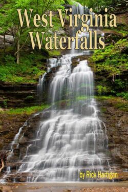
An independent source for WV Waterfalls can be found on Amazon. The author kindly allowed us to source some of our information from his exploration!
- Captain Crunch Falls – A waterfall along Laurel Creek near Beckwith.
- Coordinates: 38.111197, -81.146805 (38° 06’40.3″ N, 81° 08’48.5″ W)
- Captain Crunch Falls – A waterfall along Laurel Creek near Beckwith.

-
- Dunloup Creek Falls* – A stunning, 20-foot-tall waterfall a couple of miles southwest of Thurmond.
- Coordinates: 37.938417, -81.09752 (37° 28′18.12” N, 81° 6′36” W)
- Dunloup Creek Falls* – A stunning, 20-foot-tall waterfall a couple of miles southwest of Thurmond.
-
- Hidden Falls – A aptly-named waterfall found in Gauley Bridge. The cascade is not visible from the roadway for most of the year, except in the winter.
- Coordinates: 38.159080, -81.186608 (38° 9′32.688” N, 81° 11′11.7888” W)
- Hidden Falls – A aptly-named waterfall found in Gauley Bridge. The cascade is not visible from the roadway for most of the year, except in the winter.
-
- Kanawha Bridge Falls – A roadside waterfall along Route 60 between Charlton Heights and Glen Ferris.
- Coordinates: 38.137805, -81.216430 (38° 08’16.1″ N, 81° 12’59.2″ W)
- Laurel Creek Falls – A roadside waterfall off of Route 16 near Beckwith.
- Coordinates: 38.105931, -81.148353 (38° 06’21.4″ N, 81° 08’54.1″ W)
- Kanawha Bridge Falls – A roadside waterfall along Route 60 between Charlton Heights and Glen Ferris.
-
- Lower Turkey Creek Falls – The tallest waterfall on Turkey Creek in Ansted. The cascade stands 20 feet above the New River near Hawks Nest Dam.
- Coordinates: 38.121492, -81.129936 (38° 07’17.4″ N, 81° 07’47.8″ W)
- Lower Turkey Creek Falls – The tallest waterfall on Turkey Creek in Ansted. The cascade stands 20 feet above the New River near Hawks Nest Dam.
-
- Meadow Fork Falls – A series of short cascades on the Meadow Fork in Thurmond.
- Coordinates: 37.944922, -81.092353 (37° 56’41.7″ N, 81° 05’32.5″ W)
- Meadow Fork Falls – A series of short cascades on the Meadow Fork in Thurmond.
-
- Minden Falls – A 15-foot-tall waterfall in Minden.
- Coordinates: 37.980767, -81.136795 (37° 58’50.8″ N, 81° 08’12.5″ W)
- Minden Falls – A 15-foot-tall waterfall in Minden.
-
- Powderhouse Falls – Located on Mill Creek in Ansted.
- Coordinates: 38.122578, -81.107772 (38° 07’21.3″ N, 81° 06’28.0″ W)
- Powderhouse Falls – Located on Mill Creek in Ansted.
-
- Upper Marr Branch Falls – Located as you exit the New River Gorge on Fayette Station Road.
- Coordinates: 38.074597, -81.093042 (38° 4′28.5492” N, 81° 5′34.9512” W)
- Upper Marr Branch Falls – Located as you exit the New River Gorge on Fayette Station Road.
-
- Westlake Falls – Found on Rich Creek which empties into Mill Creek along the Ansted Rail Trail.
- Coordinates: 38.131778, -81.100167 (38° 07’54.4″ N, 81° 06’00.6″ W)
- Westlake Falls – Found on Rich Creek which empties into Mill Creek along the Ansted Rail Trail.
Nicholas County
- Cottle Falls – Cottle Falls, a series of three cascades, is located in the small town of Cottle, northeast of Craigsville.
- Coordinates: 38.349480, -80.619040 (38° 20’58.1″ N, 80° 37’08.5″ W)
- Hominy Falls – Hominy Falls is located near Mt. Nebo. The waterfall can be found right below the bridge that crosses Hominy Creek. There is parking along the roadside, just above the falls, and a path into the woods from there.
- Coordinates: 38.14543, -80.71809 (38° 08’43.6″ N, 80° 43’05.1″ W)
- Pirates Cove – Pirates Cove is a cove on Summersville Lake. It is a popular place to hang out on the water. While it is easy to access by boat or kayak from Salmon Run, you can also park and hike to the falls.
- Coordinates: 38.24313, -80.8486 (38° 14’35.3″ N, 80° 50’55.0″ W)
Raleigh County
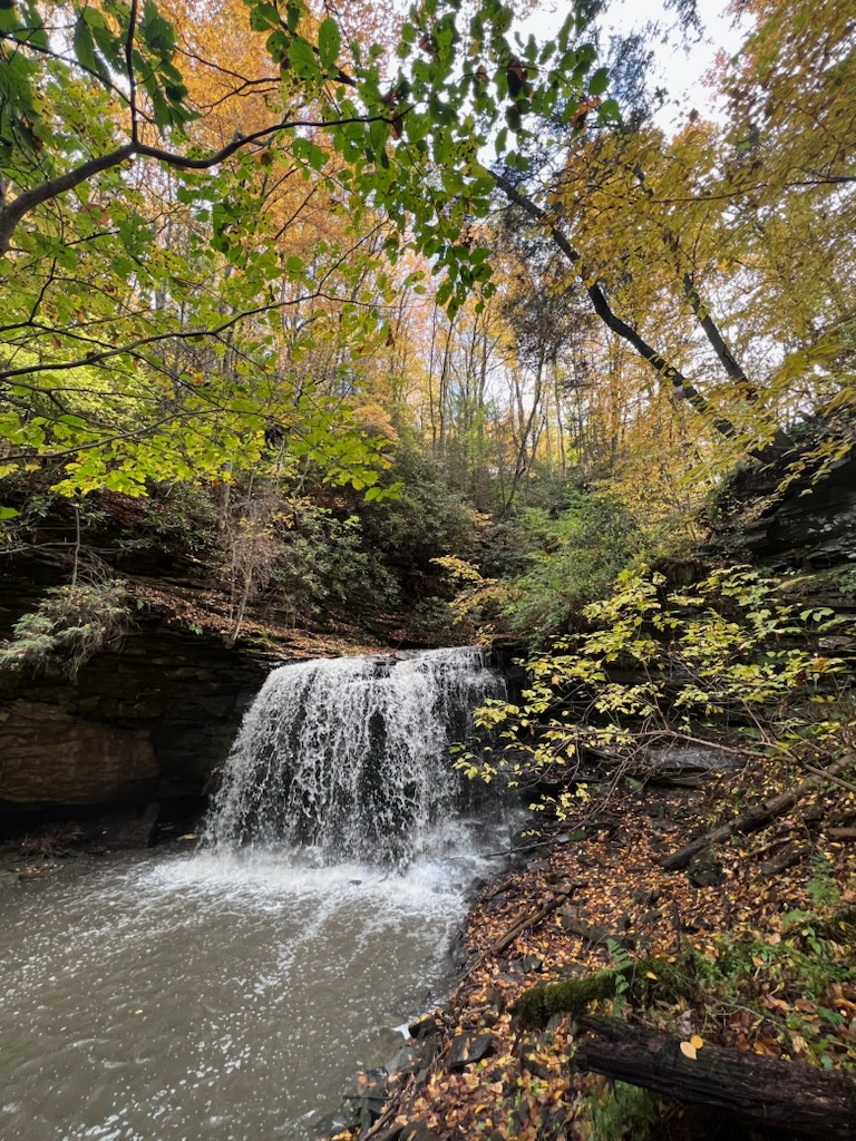
- Piney Creek Preserve – Cranberry Creek Cascades and Little White Stick Falls* – Located off the

Little White Stick Falls
newly opened Waterfall Hollow Trail on Stanaford Mine Road in Beckley. This trail splits, with beautiful falls found to the right (Cranberry Creek Cascades) and to the left (Little White Stick Falls). Large parking area and easy 1/2 mile trail.
- Coordinates: 37.793687,-81.168658 (37° 47′ 37.3″ N, 81° 10’07.2″ W)
- Kates Falls – Located off of Glade Creek, Kates Falls drapes over a cliffside, reaching into a vibrant green landscape. The falls can be accessed from the Glade Creek Trail in two directions. Just upstream from the footbridge, turn onto Kates Falls Trail — a steep, short trail that ends at a breathtaking mountain cascade.
- Coordinates: 37.776287, -81.032106 (37° 46′ 34.6″ N, 81° 01’55.6″ W)
- Piney Creek Falls – The Piney Creek trail system has 10 miles of trails that wind through the woods and butts up to the edge of the Piney Creek Gorge. Located on the longest and rather steep trail, the Beckley Mill Ruins are nestled next to the edge of Piney Creek downstream from the Beckley Mill Falls.
- Coordinates: 37.775318, -81.155487 (37° 46’31.1″ N, 81° 09’19.8″ W)
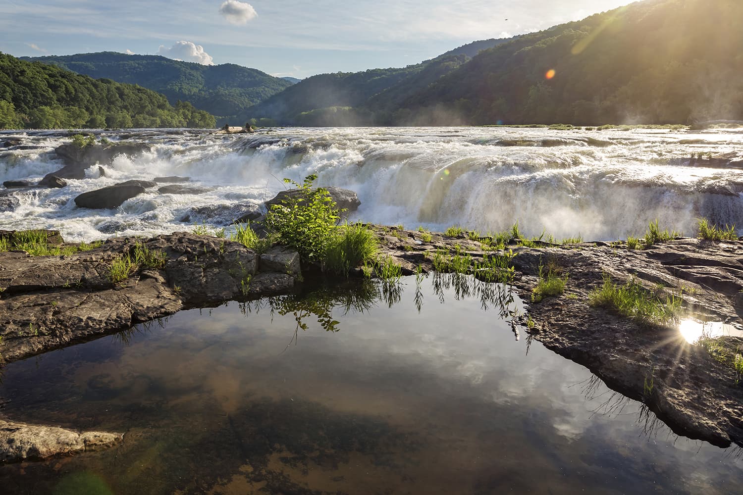
- Sandstone Falls* – Unique from the high, tumbling falls, Sandstone Falls stretches 1,500 feet wide across the New River. Learn more about Sandstone Falls at the New River Gorge National Park and Preserve Sandstone Visitors Center, then catch an aerial view of the falls from a stop along Route 20. Or, hike the boardwalk out to view the flowing falls up close. You can fish below the falls, or put on a life jacket and safely swim around.
- Coordinates: 37.756778, -80.906822 (37° 45′ 24.4002″ N, 80° 54′ 24.5592″ W)
Timeless Towns & Farm Country
 Take a stroll through the rolling hills and mountains of Summers County. Home to the largest waterfall on the New River, Sandstone Falls is a must-see when visiting Southern West Virginia.
Summers County
- Brooks Falls – Located two miles south of Sandstone Falls, Brooks Falls is a 10-foot drop and is actually classified as a Class III rapid. The National Park Service has developed a small sightseeing and picnic area on the west side of the river.
- Coordinates: 37.718083, -80.892417 (37° 43’05.1″ N, 80° 53’32.7″ W)
- Claypool Falls – Claypool Falls, also known as Meadow Creek Falls, is hidden in plain sight, no more than four miles from Interstate 64. The falls can be viewed from the road, but for a closer look, there’s a trail down to creek level. Claypool Falls spans the creek with about a 20-foot drop.
- Coordinates: 37.82360, -80.90610 (37° 49’25.0″ N, 80° 54’22.0″ W)
- Fall Branch Falls – Found on Route 20 near Hinton, Fall Branch Falls is a series of mesmerizing cascades. To find these falls, take New River Road for 6.9 miles. If you end up at Sandstone Falls, you’ve gone too far! There are ten falls in total, each beautiful and unique.
- Coordinates: 37.747472, -80.925828 (37° 44’50.9″ N, 80° 55’33.0″ W)
- Madam Creek Falls – When heading to Sandstone Falls, take the first left on Madams Creek Road for another scenic waterfall. Once you cross Madam Creek, the falls are below the bridge.
- Coordinates: 37.672943, -80.897154 (37° 40’22.6″ N, 80° 53’49.8″ W)
- Outfitters Falls – Appropriately named, Outfitters Falls sits just 50 yards up the road from an outfitter store on your way toward Sandstone Falls. Easiest to find during winter, you’ll have to look closely for it during full bloom.
- Coordinates: 37.773831, -80.890985 (37° 46’25.8″ N, 80° 53’27.6” W)
- Sandstone Falls* – Unique from the high, tumbling falls, Sandstone Falls stretches 1,500-feet-wide across the New River. Learn more about Sandstone Falls at the New River Gorge National Park and Preserve Sandstone Visitors Center, then catch an aerial view of the falls from a stop along Route 20. Or, hike the boardwalk out to view the flowing falls up close. You can fish below the falls, or put on a life jacket and safely swim around.
- Coordinates: 37.756778, -80.906822 (37° 45′ 24.4002″ N, 80° 54′ 24.5592″ W)
Historic Coalfields & Offroad Adventures
Known for the famous Hatfield and McCoy trail system, the beautiful and rugged terrain of McDowell, Mercer, and Wyoming Counties lead visitors to some of the most beautiful waterfalls in the area.
McDowell County
- Long Branch Falls – Long Branch Falls pours into RD Bailey Lake near Hanover. There is a roadside viewing area for the waterfall.
- Coordinates: 37.603579, -81.778291 (37° 36’12.9″ N, 81° 46’41.9” W)
Mercer County
- Brush Creek Falls* – A picturesque sight, Brush Creek Falls rushes 33 feet over the cliffside. Hikers can enjoy the area’s rare fauna and wildlife as they walk along the trail that was once the road to the mills that used to sit along the banks of the falls. It’s a great stop for a day of wilderness exploring, with camping and fishing available in the surrounding park.
- Coordinates: 37.466750, -81.060000 (37° 28’00.3″ N, 81° 03’36.0″ W)
- Campbell Falls* – One of two waterfalls located at Camp Creek State Park, Campbell Falls is the larger of the two and is located alongside Camp Creek Road. The waterfall measures about 15 feet high and 40 feet wide, depending on water levels. Campbell Falls descends in a series of shelves into an oval pool. The area is perfect for fishing and swimming in the warmer months.
- Coordinates: 37.517522, -81.129311 (37° 31′3.0792” N, 81° 7′45.5196” W)
- Mash Fork Falls* – Although smaller than Campbell Falls, the second waterfall at Camp Creek State Park — Mash Fork Falls — is just as captivating. This 7-foot waterfall is very wide and stunning at peak flow. There are countless spots to get different views and perspectives of this waterfall, so be sure to pack your camera.
- Coordinates: 37.500820, -81.142442 (37° 30′2.952” N, 81° 8′32.7912” W)
- Wolf Creek Falls – Wolf Creek Falls is a wonderful roadside staircase waterfall located along Route 19, near Spanishburg. The drop is between 20 and 25 feet and is dazzling when it rains.
- Coordinates: 37.471700, -81.11 (37° 28′18.12” N, -81° 6′36” W)
Wyoming County
- Alpoca Falls – Alpoca Falls is located near Mullens and is hidden most of the year. The waterfall is runoff from an underground river in the Herndon Mountain.
- Coordinates: 37.545833, -81.384444 (37° 32’45.0″ N, 81° 23’04.0” W)
- Coordinates: 37.545833, -81.384444 (37° 32’45.0″ N, 81° 23’04.0” W)
- Black Fork Falls* – The second set of falls at Twin Falls Resort State Park, Black Fork Falls, tumbles far over the cliffside like a movie waterfall, with plenty of room behind, like a secret hideaway. The trail from the first waterfall to the second is unpaved and fairly rocky. Both falls tend to dry up during the warmer months, so be sure to visit them after a little rain or in the spring and winter seasons.
- Coordinates: 37.619800, -81.456300 (37° 37’11.3″ N, 81° 27’22.7” W)
- Marsh Fork Falls* – Nestled inside Twin Falls Resort State Park, Marsh Fork Falls is one of two waterfalls that the resort is named after. One short hike from the main parking lot will lead you to both. Marsh Fork is the smaller of the two, and the first waterfall you’ll see on the paved trail, only a tenth of a mile from the Falls Trail trailhead.
- Coordinates: 37.619800, -81.456300 (37° 37’11.3″ N, 81° 27’22.7” W)
*These waterfalls are featured on the West Virginia Waterfall Trail. The trail was created for travelers looking to get off the beaten path, reconnect with nature and discover more than two dozen waterfalls for a chance to win exclusive prizes. Get your mobile passport now to start your summer adventure.